|
|
Fire
Emergency in Acre, Brazil |
|
|
|
|
ARPA
(The Amazon Region Protected Areas program) preserves a full third
of the Amazon rainforest. THE AMAZON is home to over half of the world's species. It's the lungs of the planet, and the pharmacy of the world. Email Campaigns: Sending letters and emails to elected officials is one way to let them know your preferences regarding U.S. involvement in protecting the environment.
INDUSTRY Greenspan helps industry recycle what businesses throw away.
EDUCATION Greenspan offers lesson plans: the Science Project, Environmental Education, Botany, Animal, and Ecology Guides. SCIENCE PROJECT GUIDE Do you need help with your science project? Greenspan's science project guide helps students write papers, make displays, prepare presentations, and enter the science fair.
|
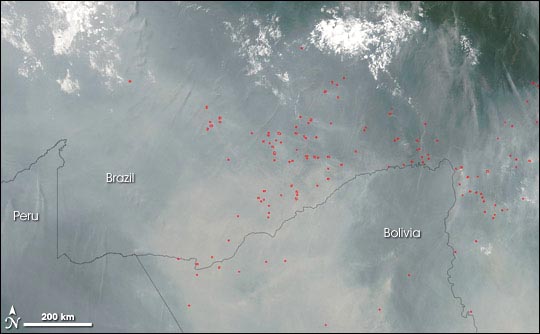
“The forests have become a tinderbox into which people are tossing lighted matches.” Those blunt words are ecologist Foster Brown’s description of the ongoing drought and fire emergency occurring around Rio Branco, a city in the state of Acre in western Brazil. The city is surrounded by farm and ranchland, which is surrounded by the Amazon Rainforest. Drought has been creeping up on the area since January 2005, when rainfall at what should have been the peak of the wet season hit a 34-year low. Since August, agricultural fires—many of them ignited in violation of a state-declared ban—have been escaping control, racing through adjacent fields and spreading into the forests. The situation continued to deteriorate through September, and record amounts of primary (undisturbed) forest may burn before the episode is over. Foster Brown is one of several NASA-funded scientists who is working with Brazilian scientists and government planners to develop strategies for controlling and preventing the destructive blazes. “Our role is to use satellite and aircraft imagery to identify sites of fire occurrence,” explains Brown, an ecologist affiliated with Woods Hole Research Center and the Federal University of Acre. Brown’s team and their colleagues at the Brazilian Center for Weather Forecasting & Climate Studies combine NASA and NOAA satellite imagery, Brazilian satellite and aircraft observations, weather forecasts, and Geographic Information Systems (GIS) data like roads, rivers, and political boundaries, to identify the areas most threatened by out-of-control fires. The combination image-maps help emergency officials decide where to focus firefighting and fire-ban-enforcement efforts, and they are also used to brief local, state, and federal officials. The satellite data are critical. Brown explained the situation via email from his temporary field office at an impromptu civil defense emergency center the government has set up in Rio Branco. “The area we are monitoring is roughly 50,000 square kilometers, and our flights right now are 1 per day with a small plane. Two helicopters are here in Acre, but their work will be ferrying workers [firefighters] and arresting those making fires.” Fortunately, Brown and his students were ready to step in and lend a hand to the emergency task force. One of his group’s research projects involves checking the accuracy and completeness of satellite-based detections of fires in the Amazon. NASA funds Brown to conduct studies on land cover and land use change in the Amazon as part of NASA’s contribution to the Brazilian-led, international research effort known as “LBA,” short for Large-Scale Biosphere-Atmosphere Experiment in Amazonia. “Our team was ready to help in the civil defense effort due to the experience of the members in field work,” said Brown. “The investment that LBA has made in education and human resource development is paying off.” Two of Brown’s students from the Federal University of Acre—graduate student Monica De Los Rios and undergraduate student Nara Pantoja—are leading the activities of gathering and disseminating information on fire occurrence for the civil defense task force. |
Web Design by
Lucid Dream
Studios